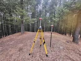
Srinagar, March 30, 2026 : In a major technological push, the Jammu and Kashmir Forest Department has adopted advanced Differential Global Positioning System (DGPS) technology to accurately survey and demarcate forest boundaries across the Union Territory.
📡 From Traditional Mapping to High Precision
Forest demarcation in J&K dates back to 1914, during the reign of Maharaja Pratap Singh, when detailed records and boundary pillars were first established.
However, over time:
- Boundary pillars got damaged or displaced
- Manual re-demarcation became slow and labor-intensive
The shift to DGPS now marks a modern, data-driven approach.
⚙️ What Makes DGPS Powerful?
Unlike standard GPS (3–5 meter accuracy), DGPS offers:
- Centimetre-level precision
- Real-time error correction using base stations or CORS networks
- Highly accurate geo-coordinates of forest boundaries
This ensures near-perfect mapping and monitoring of forest land.
🌳 Why This Matters
Officials say the move will:
- Prevent illegal encroachments
- Resolve boundary disputes quickly
- Maintain digitized and reliable forest records
- Strengthen overall forest protection systems
📊 J&K’s Forest Strength
- Total forest cover: 20,194 sq km (47.8% of geographical area)
- Kashmir region: 50.97% forest cover
- Jammu region: 45.89% forest cover
The Union Territory also has a protected area network of 4,861 sq km, including:
- National Parks
- Wildlife Sanctuaries
- Conservation Reserves
🌍 Big Picture
With DGPS-driven digitization, Jammu and Kashmir is emerging as a leader in tech-enabled environmental governance, ensuring better conservation of forests and biodiversity for future generations.


