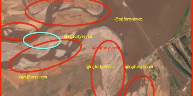
Satellite images of the Marala Headworks in the Sialkot area across the border taken on April 21, a day before the attack and then on April 26, show higher levels of silt and sedimentation ahead of the barrage.
“The water flow as observed on comparative satellite images clearly indicates decrease in the flow of water channels emanating from the headworks have reduced in size and one has totally dried up,” Col Vinayak Bhat (retd), an imagery interpretation specialist, who posted the pictures on his social media handle, told The Tribune.
“This indicates storage of water in India after suspension of the IWT,” he added.
Under the IWT signed between India and Pakistan, India had the right to use the waters of the three ‘eastern’ rivers, the Sutlej, Beas and Ravi, while the waters of the three ‘western’ rivers, Indus, Jhelum and Chenab were allocated to Pakistan.
According to the terms of the treaty, India could use up to 20 per cent water of the western rivers for irrigation and power generation through run-of-the-river projects without creating major storage facilities or disrupting the flow of water to Pakistan, whose agro-economy depends on the Indus basin.
It flows in the north-westerly direction through Chamba before entering Jammu and Kashmir, traversing the Kishtwar, Doda, Ramban, Reasi and Jammu districts and finally merging into the Sutlej near Bhawalpur in Pakistan.
The river has a high hydro-power generation potential with several operational and upcoming projects having a combined capacity of close to 7,000 megawatts on the Indian side.
The Marala Headworks, first of the four barrages on the river in Pakistan, is just about 8 kms from the International Border in the Akhnoor Sector and quite close to the Chicken’s Neck area that has been the site of decisive battles in past wars with Pakistan.
It offshoots two irrigation link canals from its left bank — the 100 kms long Marala-Ravi Link (MRL) that has a capacity of 22,000 cusecs and the Bambanwala-Ravi-Bedian-Depalpur Canal, also known as the Ichogil Canal, that is 158 kms long and has a capacity of 4,200 cusecs.
Defence experts say that many Pakistan army units have their defences based along these canals. These features form part of the operational planning on both sides as the level of water has a direct impact on the conduct of offensive and defensive manoeuvres.


